
Flooding Across the San Luis Valley: Evacuations, Highway Closures and Rising Rivers |
Updated October 26: Rio Grande at Alamosa above flood stage; Conejos River flooding and highway updates |
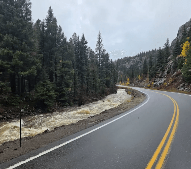
Monday morning update — Rio Grande at Alamosa above flood stage
In a National Weather Service flood statement issued at 2:48 a.m. Monday, October 26, the Rio Grande at Alamosa measured 9.9 feet at 2:30 a.m., compared with a flood stage of 9.0 feet. The NWS raised its forecast crest from 9.6 feet to 10.0 feet Monday morning. The expected impacts remain classified as minor flooding, principally in agricultural fields and other low-lying areas along the river. The river was forecast to fall below flood stage Tuesday morning; the Alamosa river warning was expected to remain in effect into Tuesday afternoon. These are the latest verified measurements and forecasts available for this update, not a live gauge reading.
Flood warnings also remained in effect Monday morning for low-lying areas between Monte Vista and Alamosa and along the Conejos River near Manassa, with the latter warning extending into early Tuesday. No newer confirmed change in evacuation orders or highway reopenings was established at the time of this update. Check NWS Pueblo, COtrip and Conejos County Public Health for current conditions.
Sunday evening update — highways reopen, Wolf Creek Pass repairs continue
In a CDOT report issued at approximately 5:47 p.m. Sunday, October 25, transportation officials confirmed the reopening of US 285 north of Monte Vista and CO 112 between Del Norte and Center. CO 17 south of Antonito had reopened Saturday. US 160 over Wolf Creek Pass remains closed due to multiple damaged roadway locations requiring emergency repairs. The latest previously reported National Weather Service forecast called for the Rio Grande at Alamosa to crest near 9.6 feet Monday morning, above the 9-foot flood stage; this is a forecast, not an observed crest. The status of Manassa and Guadalupe evacuation orders should be checked directly with Conejos County officials.
Flooding Across the San Luis Valley
Heavy October rainfall has brought flooding to the Rio Grande and Conejos River corridors, prompting evacuations, damaging property and disrupting travel. This report includes updates through Monday morning, October 26, with information from county emergency officials, National Weather Service reports and CDOT road notices. Conditions may change rapidly.
Conejos County: Manassa, Guadalupe and Antonito
Conejos County Public Health, coordinating with the Sheriff's Office, reported Sunday morning that evacuations remain in effect for Manassa and Guadalupe. The National Weather Service also reported flooding along the Conejos River near Antonito and Conejos on Friday, with earlier evacuation reports along portions of the river near Antonito. The current status of those particular Antonito-area evacuation orders has not been confirmed. Other communities identified in flood warnings include Sanford, Romeo, Ortiz and Bountiful; being named in a warning does not necessarily mean flooding has been confirmed in each community.
Shelters, animals and sandbags
The Knights of Columbus Hall in La Jara is available as a shelter for evacuated residents. La Jara Arena, 17705 US 285, is accepting small animals and livestock only. For animal shelter assistance, contact Mystie Hoyt at 719-298-1099. The arena cannot accommodate household pets. County officials said additional pet accommodation information would follow. Self-fill sandbags were offered at the Conejos County Courthouse from 9 a.m. to noon Sunday, October 25; that distribution window may now have passed.
South Fork and Fun Valley
Earlier National Weather Service storm reports described flooding of homes west of South Fork, debris and water crossing US 160, and the Park Creek Bridge washing away. At Fun Valley, emergency responders reported severe flooding, including recreational vehicles dislodged and carried into the river. Evacuations were reported between Wolf Creek Ranch and Fun Valley during the initial emergency; current orders should be checked with local authorities.
Del Norte and Monte Vista
The Rio Grande rose above flood stage near Del Norte on Friday, with flooding threatening low-lying roads and properties. Farther downstream, the National Weather Service reported flooding in low-lying agricultural areas between Monte Vista and Alamosa. This does not establish flooding in downtown Monte Vista. US 285 north of Monte Vista was closed earlier because of flooding, but CDOT reported that the highway reopened Sunday afternoon following inspections.
Alamosa and downstream flooding
At 7:30 a.m. Sunday, the Rio Grande at Alamosa was reported at 6.8 feet. The National Weather Service initially forecast a crest near 9.2 feet Monday morning; a later Sunday forecast raised the expected crest to 9.6 feet, above the 9-foot flood stage, with minor agricultural flooding expected. This is a forecast, not a confirmed Monday river reading. A separate flood warning affected northeastern Conejos and southwestern Alamosa counties into Tuesday morning.
Highway status — Sunday evening update
CDOT's Sunday evening update reports that US 285 north of Monte Vista (mileposts 51–56) reopened at approximately 1:40 p.m. Sunday, and CO 112 between Del Norte and Center (mileposts 1–13) reopened shortly after 3 p.m. following bridge and highway inspections. CO 17 between Antonito and the New Mexico state line (mileposts 0–38) reopened Saturday at approximately 8:30 a.m. These reopenings supersede the earlier closure reports.
US 160 over Wolf Creek Pass remains closed. CDOT has reported damage requiring emergency repairs at milepost 150 (failed culvert and sinkhole), milepost 161 (retaining wall damage), and mileposts 176–180 (damaged shoulders and undermined roadway). No reopening date has been announced. The extended closure affects the Wolf Creek Pass corridor between mileposts 150 and 183. Motorists should consult COtrip before traveling.
Other Valley counties
Heavy rain was also recorded in Costilla County, including near Blanca, Fort Garland and San Luis, but specific flood damage there has not been independently confirmed in the reports reviewed. Flood and travel impacts in Mineral and Saguache counties should likewise be described only where confirmed; this report does not imply every Valley county has sustained flood damage.
Stay informed and share information
Follow current warnings from the National Weather Service, road updates at COtrip, and evacuation or shelter announcements from Conejos County Public Health. Never drive through flooded roads or around barricades. The San Luis Valley Beat welcomes verified firsthand reports and photographs from affected communities at editor@thesanluisvalleybeat.com. Do not enter restricted or flooded areas to take photographs.
Updated Monday morning, October 26, 2026. Road closures, evacuation orders and river forecasts can change; verify current conditions with officials. |
0 Comments
Join the conversation
Be the first to comment
Share your thoughts above.