
The Vanishing Lake: When the San Luis Valley Was Underwater |
Long before today's farms, towns, and highways, an enormous lake covered much of the San Luis Valley. Its disappearance helped shape the landscape we know today. |
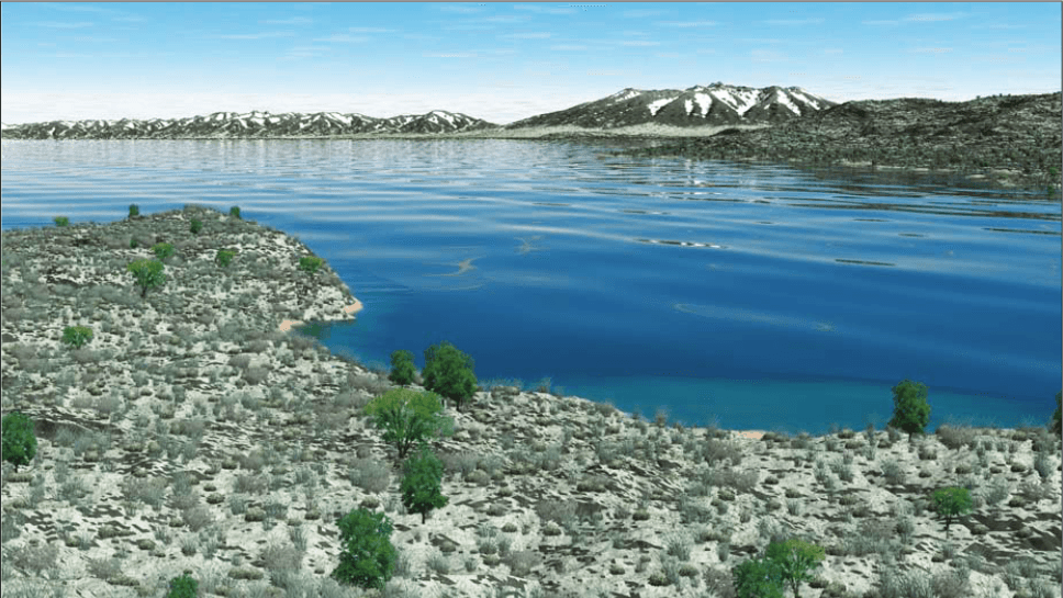
Imagine standing near Alamosa hundreds of thousands of years ago and looking across a vast expanse of water instead of the open valley floor we see today.
The Sangre de Cristo Mountains would still rise to the east, and the San Juan Mountains would stand to the west. But between them, much of the basin would be occupied by an enormous prehistoric lake.
Scientists call it Lake Alamosa, and its story is one of the most remarkable chapters in the geological history of the San Luis Valley.
A Lake Hidden in the Valley's Past
Lake Alamosa existed during the Pleistocene Epoch, a period marked by repeated advances and retreats of glaciers across North America.
Water flowing from the surrounding mountains collected in the northern portion of the San Luis Basin, where natural barriers prevented it from draining freely southward.
Over thousands of years, sediments accumulated beneath the lake, leaving behind geological evidence that researchers can still study today.
Unlike the Great Lakes, Lake Alamosa was not a permanent feature of the landscape. Its size and shoreline changed as climate, water supplies, and geological conditions evolved.
How Big Was Lake Alamosa?
At its greatest extent, Lake Alamosa covered a substantial portion of the San Luis Valley, although scientists continue to study its precise boundaries and changing water levels.
The ancient lake occupied an area now associated with communities, agricultural land, wetlands, and open rangeland.
Today, there is little obvious evidence of such an enormous body of water when driving across the valley floor.
But beneath the surface, layers of lakebed sediment help tell the story of a landscape that once looked dramatically different.
What Happened to All That Water?
The most important turning point came roughly 400,000 years ago.
Geological research indicates that Lake Alamosa eventually overflowed or breached a natural barrier near the southern end of the basin.
Water began escaping southward, cutting into the landscape and establishing drainage through the area now occupied by the Rio Grande Gorge.
As erosion continued, the lake's water level dropped and the broad lakebed was gradually exposed.
This was not necessarily a single sudden event in which the entire lake disappeared overnight. Scientists describe a complicated process involving drainage, erosion, and changing water levels.
The result, however, was extraordinary: a once-enormous lake gave way to the broad, high-altitude valley familiar to residents today.
The Birth of a River System
The disappearance of Lake Alamosa played an important role in the development of the modern Rio Grande drainage.
Before the lake drained, water in the northern San Luis Basin was largely trapped within the basin.
Once an outlet developed, that water could flow southward and become part of the larger Rio Grande system.
Over time, flowing water carved deeper channels and helped shape the river corridor extending into northern New Mexico.
The Rio Grande that winds through the San Luis Valley today is part of this much longer geological story.
What Does This Have to Do With the Great Sand Dunes?
The ancient lake also helps explain the remarkable landscape surrounding Great Sand Dunes National Park and Preserve.
As water levels changed and sediments were exposed, wind could transport sand across the basin.
That sand, along with material supplied by streams and erosion of the surrounding mountains, became part of the natural system that eventually produced the great dune field at the foot of the Sangre de Cristo Mountains.
The dunes are not simply a pile of sand left behind by one disappearing lake. They are the product of a much more complicated interaction among wind, water, mountains, and sediments over an immense span of time.
Lake Alamosa is an important part of that story.
The Evidence Is Still Here
Although Lake Alamosa vanished long before humans established today's San Luis Valley communities, its geological legacy remains.
Researchers have studied ancient shoreline features, lakebed deposits, sediments, and the changing drainage patterns of the region.
These clues help scientists reconstruct the valley's prehistoric environment and understand how the landscape evolved.
For residents, that means the seemingly flat land stretching between the mountains holds evidence of a very different world.
Fields, roads, and communities now occupy areas shaped by geological processes that began hundreds of thousands of years ago.
A Valley That Never Stops Changing
It is easy to think of the San Luis Valley as an unchanging landscape.
The mountains seem permanent, the open spaces appear endless, and the Rio Grande follows a familiar course through the basin.
But the story of Lake Alamosa reminds us that even the most recognizable landscapes have undergone enormous transformations.
Where there is now farmland, there was once open water. Where the Rio Grande flows today, ancient drainage systems were still developing. And where visitors now climb the Great Sand Dunes, wind and water have been shaping the land for countless generations.
The next time you look across the San Luis Valley, imagine an ancient lake stretching toward the mountains.
The water is long gone, but the story of Lake Alamosa is still written into the land beneath our feet. |
1 Comment
Join the conversation
I was born & grew up in Alamosa, although I haven’t lived in the Valley for years, it’s still like home. I look forward to learning more about it.